I'm pleased to say that after a period of digital struggle, we have successfully created circular polarization ratio (CPR) images for our new radar images.
This past summer, our team requested that the Canadian Space Agency take some new quad-polarized radar images over Axel Heiberg Island (my favourite place!) We were able to obtain these images through the CSA's Science and Operational Applications Research (SOAR) grant program. SOAR has provided four Ontario universities with funding to explore applications of RADARSAT-2 to benefit Canada for geological mapping, environmental monitoring, agriculture, and infrastructure risk management. Our team at Western is focusing on geological mapping and resource exploration in the Canadian Arctic, hence our wonderful blog, "Arctic Resolution".
Processing our new images has proven to be a tricky process. For reasons still unknown to us, we had previous difficulty trying to produce terrain corrected CPR images. I have previously written about the importance of terrain correction, so you can see why this was quite the problem! What was happening, was that our radar data was "flipping" itself horizontally, while still maintaining the correct outline of the images files. This baffled us, because we would have images which were ostensibly terrain corrected (the edges of the land and ocean were all lining up properly) but the data on the inside were all backwards (the radar was showing mountains and salt diapirs in the wrong places). We could either create circularly polarized images, or do terrain corrections, but not both.
Fortuneatly, after giving the computer some alone time, we don't seem to be experiencing this problem anymore. So yay!
It was a three-program process to make the terrain corrected images. Here's what we did:
- Opened the original files in PolSAR-Pro
- Created a C3 matrix (used for finding CPRs)
- Changed the elliptical basis to Circularly Polarized (needed for CPRs)
- Imported data from PolSAR-Pro into SNAP (formerly Sentinel-1 Toolbox)
- Multilook Processing
- Create CPR expression using Band Math tool
- Terrain Correction
- Export as BEAM-DIMAP
- Open exported file in ArcGIS
- Overlay your new CPR images over base layers to see how they compare
- Stretch the images as per your choosing (we like 0-1 on a rainbow colour ramp)
- Smile at your success
Here's what we made!
a)
 |
b)
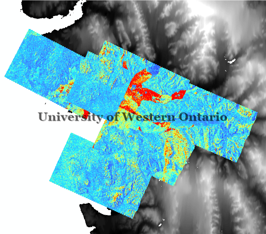 |
CPR (0-1 stretch) of RADARSAT-2 2016 acquisitions. Images overlay one another.
a) water at elevation = 0 is masked out b) water is included
|
Our job is not done, however. It is noticeable that there is some overlap in our radar coverage, and the values aren't exactly the same! A lot of the discrepancy is from the water, where variations in wind on the different days of acquisition can cause different wave heights which will cause variations in radar scatter. However, there are some discrepancies on land, too, which are a little bit trickier to explain. In order to mosiac (combine) these images into one product, we will need to decide how to deal with the overlapping parts. These data are continuous, so blending or taking the average of the values may be preferable tactics. Mosaicking will be the next step, and then we can start comparing how the radar signatures over the evaporite exposures, as mapped by Maria.
Cheers!
RADARSAT-2 Data and Products (c) MacDonald, Dettwiler and Associates, Ltd. (2016) - All Rights Reserved. RADARSAT is an official trademark of the Canadian Space Agency.